The skies were clear again this morning, but the forecast was for clouds coming over for the afternoon ... the avalanche risk was still high at 3 and the winds wee fierce high up ... so another day of lower level touring ... after the success of yesterdays route up the valley we opted to go up the next valley along, heading for the Heinrich Hueter hut.
The route started whee the road was blocked at a coup of bridges, and an obvious parking area.
However despite the recent snow the start was going to be a walk. We could either walk up the road on the right hand (sunny) side or the valley or follow the summer trail on the left hand side. (Remind me about summer trails through the woods next time please!!).
Crossing the second of the bridges we moved onto the snow, but this was in patches, as the path meandered up the side of the stream in an obvious route.
very little to indicate the issues that would follow later .. we would reflect on this route as the winter obstacle course
Still carrying the skis as the snow cover was patchy, but where the snow was, and with the lack of any serious overnight freezing ... obstacle #1 ... heavy pack weight, low surface tension = post holing with every step.
By now the route was still discernible but was beginning to be camouflaged in places.
Time for the skis ... avoiding the really steep bits, but still following a hint of a trail. The river beside us had a number of "check" barriers to control the surging, and the GPS showed us on track.
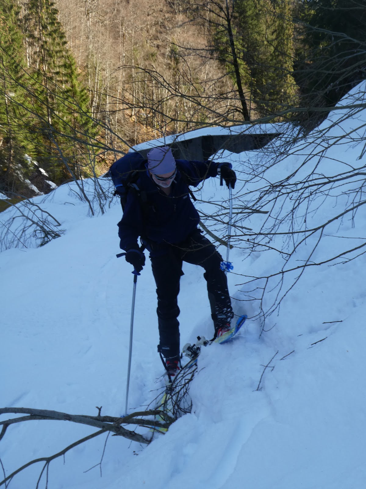
Obstacle #2 ... a bush was bent across the trail, and buried in the recent snow.
Awkward steep side step to get over the trunk end and avoid the neighboring bush.
Obstacle #3 ... a stream with deep sides .. getting down was not too bad .. a long(ish) step and you were in the water Getting up the other side was more of a problem .... for some reason there was no way I could lift my leg up high enough to reach the top, and all attempts to cut a step failed to provide anything satisfactory enough. .. So final resort .. skis off and front point up.
Obstacle #4 ... descent into the river plain and then maneuver amongst the holes... the path trail had disappeared completely and the only route was to drop to the stream and follow it to the control station. it required control that sliding would not be possible and needed to step down, then a maze trail through the holes (a bit like crevasse avoidance).
From the control station (which had a road descending to it) the map showed the path continuing a little higher. We found the start of the trail and followed it into the woods (again you know what is about to follow!).
Once more the trail was initially easy to see and follow as it rose steeply into the trees.
As the trial began to fade slightly we knew we were still OK as there was a bridge ahead...
Obstacle #5 ... getting down to the bridge ... slide, side slip and step down all involved careful not to slip down into the deep gorge under the bridge.
some of the snow was hard packed and solid after the rain and others parts had soft patches. To add to the variety there were also a few bushes scattered around.
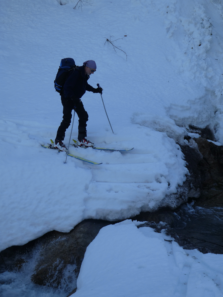
Once at the bridge .. Obstacle #6 .. getting onto it ... what the view from above does not show is the height of the snow bank at the end (and its verticality). another time to step out of the skis and climb down.
The path on the other side was marked by a chain fence ... so knew where it went (or so we thought ....)
Once around this edge it vanished from sight and we were left on the steep wooded hill side, and to make matters worse the GPS was wandering around presumably because of the tree cover!
Heading off in the general direction we wanted to go making our way through the trees.
Obstacle #7 ... setting off across the slope in the direction of where the map showed a bridge ..
A huge tree was across the route we were taking blocking all progress ... skis off again and climb thorough.
Obstacle #8 ... the bridge was up there some where ... presumably at the top of the controls.. however the only viable way was to descend to the river ... across a soft snow with very weak bonding.
Once down I was prepared to boulder hop across (some dodgy descend into the river, balance over the boulders and up the other side), when a more obvious route came into view.
My idea, so me pathfinding ... Obstacle #9 crossing a torrent on skis. step down, then the snow bridge collapsed ... wade across a few steps and out the other side to safety.
Bryon took a giant leap for mankind and stepped over.
Once over it was a steep climb up the other side and to the top of the control gates under a small wooded knoll.
From here the obvious route went up the wide gully running down to the control gates, and the bridge ... the top of this we could see the road that had come along this (right hand) side of the stream. The road was blocked by a large avalanche which had left debris all down the gully, and with the soft snow made fro an interesting ascent trying to pick a route through were you were not teetering on ice/ dirt blocks nor falling into soft snow covered holes.
On the road, it was surprising to see a track coming up the other side of the knoll, from the bridge .. presumably the avalanche is a common event.
Now on the road bed, the skining got easier, with a gentle constant gradient. but still soft un-tracked snow, showing no one has been this way in a while.
The road went on and on .. a few minor slides in the couloirs, but essentially making the way towards the back oft he valley.
The we passed obstacle #10 . another large avalanche run-off, with some huge chunks to circumnavigate.
Then around the next bend we met obstacle #11 ... another tree across the road, this time we went under, but this involved removing the rucksacs to get through.
From here we popped out on the upper meadows ... we knew we were here as we passed through the dismantled stock gateway.
Below the hamlet was a snack shack - closed for the winter
The time was passing and we really ought to be heading back... the sun had been on the snow for a long time and the evidence of the avalanches showed what could happen if we dallied.
This meant we would not get to the hut, but we had come to the back bowls.
So at the meeting of the summer track (left hand route which had continued even after we had abandoned it) and the road was a natural stopping point.
We had a quick bite before debating the return.
The snow was too wet and heavy to glide easily and the gradient not really steep enough here so we skinned and slid down the way w had come up ... keeping in the tracks we had made helped greatly.
As we weft the top pasture area and passed the gate again, then back to the tree obstacle.. same contortions to get through ... after this I pulled off the skins whilst Bryon kept them on up to the next avalanche field with the big boulders. The gradient had increased and I could control the speed dipping in and out of the train tracks.
Before anytime we reached the massive avalanche where we joined the road - obstacle #12.
Here it was time to get off the skis and pick a way across.
On the other side we could see evidence that the avalanche had been there before the latest snowfalls and the clear up had started but halted by the latest snow.
The consequences of this was that the road had been cleared, and hence the snow cover was now just slush as the tarmac was radiating heat.
Now it was a long walk back to the car carrying the skis.
After a long walk down ... we were back at the car ... on reflection, and despite the obstacles, the route through the forest was better than walking up the road ... the additional time taken had meant we did not make the hut, but we had a good day out.
The consequences would, however, be felt in the following days, where the long down hill tramp had impacted Bryon's knees.
We stopped off at Lidl for supplies on the way back to the apartment.
Dinner was pork goulash and the remains of yesterdays's,pasta.