The area of High Pressure over us was not moving, and we woke to a frost and
blue skies. It was too good a day to ignore, so Bertie and I headed out
towards Witley. I wanted to explore around Mousehill Down and had worked out a
route taking in Parts of Ockley common, then back through Thursley nature
reserve, and Witley common.
The other area of decision was Wellies or walking boots. After last time I erred
on the side of Wellies (or rather snow boots this time). However as opposed to
last time my decision was wrong - apart from one small area under water the rest
was either dry sand or lightly muddy tracks. I did decide that I need to add
some laces to the snow boots for a tighter fit.
The car park is entered via a height restricted lane off the south bound slip
road for the A3, and an underpass to a dirt parking area. This was very
popular even on a early weekday morning, and we quickly disappeared into the
woods uphill heading north.
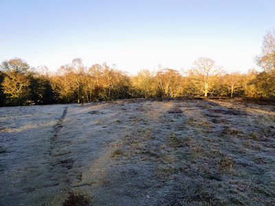
The high point of the down was open, and the grass all frosted. The trees picked
up in the rising sunlight.
We dropped down the other side to the end of a lane from Witley, before taking
the footpath heading West
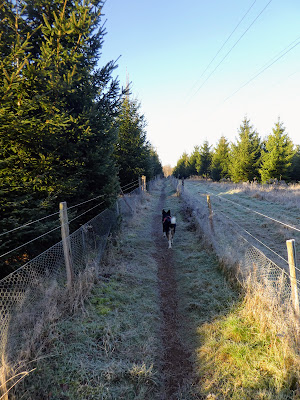
Traversing a Christmas tree plantation on a fenced in path, before coming out to
water meadows beside Bagmoor Cottage. This was the only time where Wellies were
needed today, in fact i could have been better off in waders, such was the depth
of the water when the odd branches dipped deep into the puddles. I would
complete the rest of the walk with a small amount of muddy water inside the
right boot.
Entering into Bagmoor Common, which soon opened out into heathland with grasses
and gorse
The sun peeking over the trees bounding the common, as we followed a windy path
through the grasses.
Transitioning into the MoD training area was almost indiscernible, just slightly
wider tracks.
The track merged onto a driveway just after the pond and led towards Elstead
village. However we took a sharp left hand turn following the boundary of the
MoD training area.
The track veered away from the boundary and cut into the training area. After a
cross roads this track turned into a wide vehicle track running down the side of
a wood
Opening out onto Elstead common and beside a number of ponds. The common was
very flat grass land (with large "deep bog" warning signs to keep casual
visitors on the tracks.
There was a large car park at the end of the track, in the trees, next to a
large pond (the Moat), which we circled for good measure
Then back through the trees and out onto the open common (now called Thursley
Common) following a track much the same as the last one, just heading south.
The next section was slightly contrived, as the best route south was something I
had already explored on our Hankley Common walk. so we continued up the road
towards Hankley common car park, before turning south down Houndown Bottom. This
MoD Training area was closed today as the army was on exercise, luckily we were
the open access path. We took a path to the side of the road - sandy so was
harder work, but more enjoyable than the road.
The sun creeping through the trees of Houndown and causing steam to rise from
the bushes where it landed. We turned off where the boundary road turned east,
following it.
The path on the map goes up two sides of a triangle then uses the road to come
back to the middle on the other side. However there was a path up through the
woods on a direct bearing and then down the path n the other side of the
road.
This had also been part of the Hankley common walk, except we cut up the drive
to Smallbrook. This would take us to the Greensand way to the village of
Thursley.
I recognised the GSW junction from my walk coming down from Devil's Punchbowl.
We followed this until it came out at the church in the village of Thursley.
This time we veered to the left hand side of the church and through the car
park. Up the road to the main part of the village and a triangle green.
Across from the green we took wide track leading into Thursley Nature
Reserve.
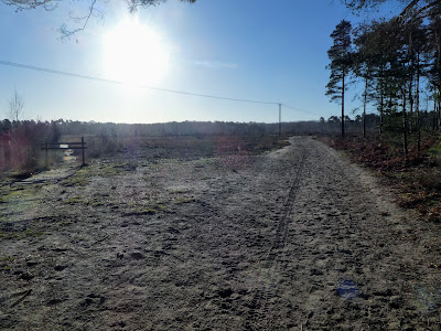
The track followed the southern boundary of the reserve, on a wide sandy trail,
enclosed to start with.
Around the point where we tracked the slip road for the A3 junction, things
opened up a little as the ground undulated.
Dropping down into a valley with lakes marked on the map, but the first one was
dry. the sun coming through lighting up the scots pines
A straight(ish) track through the forest, heading north
Dropping down to the large Forked Pond, still frozen and reflecting the sun, then a smaller track around the edge. From here we crossed over the river and followed a gravel track to the Borough Farm.
Leaving the farm and into Witley Common. the track had been recently maintained and was a wide hoggin road, which we followed as it contoured through the woods around Rodborough hill
At Mousehill Corner we left the track as it merged into the house drive and became a dirt track. We cut through the woods on one of many tracks heading in the general direction of the carpark.
Back at the van the car park was still busy (although now changed to the lunchtime dog walkers). Time for lunch and a coffee.