
On my way back I counted them... 16 pedestrian gates and 12 stiles, three farm gates (two were open) and there was also one stile and one gate missed by using a farm track. In their defence there were a lot of sheep with young lambs so I guess dog bypasses could be a problem.


The other side rose back up to the Llandrindod Wells road trough sheep
pasture.


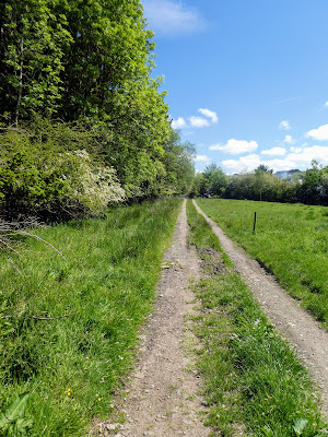
 Across the road and into a hay field rising slightly again. followed by
another one before reaching the top of slope and going over and down the other
side.
Across the road and into a hay field rising slightly again. followed by
another one before reaching the top of slope and going over and down the other
side.


The path was not clear across these fields, so just followed a vague
direction.

 Down to a stream with a few stepping stones to cross - Bertie taking a dip for
the second time today. The gate on the edge above showing the way.
Down to a stream with a few stepping stones to cross - Bertie taking a dip for
the second time today. The gate on the edge above showing the way.


 Climbing up the other side through more hay fields - filled with buttercups.


At the top of the rise we met with a track from the right and turned left.
Along the hedge line to a gate and also a collection of sheep.
Beyond the path dropped down again to run along side a farm track ending in a
boggy bit next to another stream. We were on the right path as the gate lead
out of the wood to the track after the stream.
On the other side of the track the path rose up again to a wooded area,
however the gate area was filled with cattle, so we took and executive
decision to go up the other side of the hedge in the next door field

 Crossing over the fence into the woods at the top of the rise, showed a
pleasant bluebell wood, and the track leading down a steep bank to the river
Ithon
Crossing over the fence into the woods at the top of the rise, showed a
pleasant bluebell wood, and the track leading down a steep bank to the river
Ithon


 The path ran along the river opposite a mobile home park, then a field leading
up to the road and the bridge at Disserth.
The path ran along the river opposite a mobile home park, then a field leading
up to the road and the bridge at Disserth.


We did not go to the church, but continued after a bit of working out where we
were on the GPS .. I missed having a large map to orientate myself.


 Having crossed over the bridge the path climbed up the slope above the river
and into another field. Over the top and down the other side.
Having crossed over the bridge the path climbed up the slope above the river
and into another field. Over the top and down the other side.


Out the other side we came out into a large pasture area that ran down to the
railway and the road along the bottom of the valley. There were the remains of
a roman road (leading to Roman practice works on the map)
 At the end of the pasture fields the path turned into a track that led to a
gate onto the farm track. this track crossed over the railway tracks before
meeting the main road from Builth Wells
At the end of the pasture fields the path turned into a track that led to a
gate onto the farm track. this track crossed over the railway tracks before
meeting the main road from Builth Wells

 We followed the road on the footpath for a while before identifying a cut
through leading to Rock Park ... this was not intentional, but rather
determined from a desire to get off the road, however later we saw it was the
published route.
We followed the road on the footpath for a while before identifying a cut
through leading to Rock Park ... this was not intentional, but rather
determined from a desire to get off the road, however later we saw it was the
published route.


We did have a bit of a false start as I went up the wrong road (no way across
the rails), before doubling back and going under the railway at the right
place.
We followed the path on the other side as it cut back through a common area
(more roman works) and then into the Rock park area.


 this was a piece called Russel ... a recumbent dog, then on around
to the spring ... very mineralised water, and the 4 kings seats, looking
over the stream.
this was a piece called Russel ... a recumbent dog, then on around
to the spring ... very mineralised water, and the 4 kings seats, looking
over the stream.

 following the path back out of the Park, through the spa gates, and back up
into the town.
following the path back out of the Park, through the spa gates, and back up
into the town.

 We walked on to Tesco's past the station with its restored Victorian signal
box and station platforms, then back over the railway lines to find a
refreshment stop
We walked on to Tesco's past the station with its restored Victorian signal
box and station platforms, then back over the railway lines to find a
refreshment stop

 Back through the town and the parks before we separated beside the road up tot
eh lake and common area. I set off back for Newbridge, the others would
explore the lake area and wait for me to return with the van.
Back through the town and the parks before we separated beside the road up tot
eh lake and common area. I set off back for Newbridge, the others would
explore the lake area and wait for me to return with the van.


Apart from the initial section along the road I followed the same route back
as we took on the outward journey - this time counting the barriers.
Slightly different horizon as to the other way around, with the hills beyond
Newbridge.


