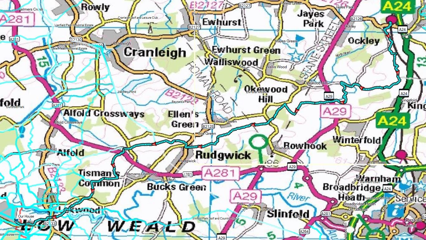
I decided on a change from the normal circular routes and picked out a linear
one - making use of the railways to get to Ockley near Capel, then heading
south to the Sussex Border Path (SBP) then following this back to Rudgwick and
the Downs link. Before reaching the Rikkyo school cut off to Barnsfold then
down the side of the clay pits development and down to the canal at Brewhurst.
Finally following the well worn path back home.
Bertie and I hitched a lift to Billingshurst station as Sue was going to work.
We arrived just as a train arrived so we hopped on getting to Horsham, where we
had to then wait for the connection.
Second train up the Dorking route to London Victoria. Getting off at the rural
station of Ockley - no where near the village. To get out we had to cross under
the lines then down the station approach to the B2126
Across the road down a twitten that cut behind a row of gardens to come out on a
back road
Down the back road and around a corner merging onto Weare Street. Leaving onto a
wide track into Knoll wood.
A strange zigzag through a field to get to the farm yard of Knoll Farm
Beyond Knoll farm and over a slight hillock to approach the Osbrooks - a large
house with a farm and workers cottages surrounding it.
Around the back of one of the cottages we dropped down a path into the woods,
and over the field beyond.
WE arrived at a complex of farm buildings where we met the SBP. Now following
this heading towards teh West.
The path merged onto the drive for Wattlehurst farm, and we followed this
ancient lane as it wound around the buildings.
The lane passed the large buildings of Oakdale farm and down its drive (called
smugglers lane)
The driveway exited onto the continuation of Weare Street that we had followed
earlier, before we picked up a green lane heading away from the road.
The lane merged into a driveway for Place farm, which we left beside a large
pond. Then cutting through the woods (I think the route had been diverted around
the woods, and we caught up with it at the edge of a field.
We came out into a field and followed it to a second one where the path
dissolved into the grass. We headed in the vague direction of the farm buildings
on the slkyline.
Unfortunately there was no way across the stream in a deep gully, and we tracked
back along it to find the real path through a pair of overgrown gates.
Leaving the fields as we came to the farm drive, and hence the yard of Denne
farm. Continuing down the driveway to reach the A29
Straight across the main road down beside some crop fields.
Turning onto Rickmans Lane (on the line of the old Roman Stane street). This
section of the SBP follows a number of old lanes.
At Monks Farm we turned up Monks lane - a gates road leading up to a back
road.
A sharp turn back down another ancient track, past a gatehouse, and into the
woods.
The SBP left the ancient track when it went into Honeywood house and we
continued along the boundary to a back road. Across the road and down the
driveway to Ridge Farm.
Ridge farm was mainly industrial units of various types, however we followed the
track through the middle and out the other side.
The track led to a second farm - St Austen's farm - which actually had
livestock, and went through that one as well, continuing on the lane beside
pasture fields.
The track continued on towards Hermongers ... the SBP was supposed to
circle around it, however we could not find the path junction and continued on
the track into the repurposed farm buildings and on down the driveway.
Picking up the SBP again by crossing a grass field - there was some confusion
between the field and the woods (no footpath signs, and lots of keep out ones
instead) . Around the end of the woods we picked up the true path once again.
Approaching Rudgwick village across the fields coming out in the church yard. We
paused here for a snack and a drink - Bertie was only interested in the food
though!
On into the village, passing the back road to the Fox Inn and then down a
twitten between houses leading up Little Hawks Hill.
We followed the boundary of the clay pits - another on-going renovation project,
and we met the Downs link.
This joined the SBP up the hill then left it as we continued out the other side
of the hill
Finally a view - most of the walk had been on old lanes and enclosed paths
with only sparingly views. Looking across to the south Downs.
Across cow pasture, dropping down to woods of Hobbs copse.
In the woods we dropped down and over a stream, before climbing past the deer
herd
Coming out opposite Hillhouse lane, we would leave the SBP here after finding a
path down a crazy drive, eventually coming out into a rough field. This led to
the A281, where we braved the traffic to find the footpath on the other side.
This was the sight at the footpath sign ... I had to trample the brambles
down so that Bertie could get through. We then followed a wide forestry track
through Hornshill wood as it curved down to the south,
The woods tapered out and we followed a stream past a collection of houses and
down their driveway to a back road.
Walking down the back road to its conclusion at Barnsfold farm house, then
continuing on along the lane beside it.
We then entered to woods beside where the Loxwood clay pits wants to take over.
we followed the edge down to the Loxwood road and the large layby.
Crossing over Loxwood road heading down to the canal through the woods and
around a ploughed field.
Catching up with the canal at Drungewick lane crossing. From here it was a
simple often followed route home, up the lane and across the fields to the
Plaistow road, then through the village home.